

Space Situational Awareness: Keeping the Space Blips from Bumping
Government Agencies and Private Companies Each Have Roles to Play


As Earth orbit becomes more crowded with constellations of thousands of satellites, CubeSats, SmallSats, defunct satellites and space debris, Space Situational Awareness (SSA) becomes a critical factor in making sure all those expensive satellites can accomplish their missions.
In aviation parlance, Air Traffic Control is sometimes referred to as the art of “keeping the blips from bumping”. In space, the number of “blips” is exponentially larger, and while space is also much larger than the airspace above the Earth, the blips are also moving as much as 17,000+ miles per hour. So, keeping the blips from bumping becomes an impossible task for a human operator alone.
SSA relies on a variety of advanced technologies. Radar systems, both ground-based and space-based, are used to track objects in low Earth orbit (LEO) by bouncing radio waves off them and measuring the return signal. Optical telescopes, also ground-based and space-based, observe objects in higher orbits by capturing their reflected sunlight. Laser ranging systems use lasers to measure the distance to an object by timing the reflection of laser pulses, providing highly accurate tracking.
Public-Private Partnerships
Data processing and analytics play a crucial role, with advanced algorithms and artificial intelligence (AI) enhancing the accuracy and efficiency of data analysis and prediction. Satellite constellations, including CubeSats and SmallSats, offer comprehensive coverage and real-time data on space objects. Space-based sensors, such as infrared and multispectral sensors, detect heat signatures and provide detailed information about the composition and behavior of space objects. Communication networks, including ground stations and inter-satellite links, facilitate data transmission and command relay.
One of the efforts to improve Space Situational Awareness involves a public-private partnership between NOAA’s Office of Space Commerce and multiple companies called the Traffic Coordination System for Space (TraCSS). TraCSS is designed to provide basic space situational awareness (SSA) data and services to civil and private space operators and to support spaceflight safety, space sustainability, and international coordination. Nine satellite operators – NOAA, Maxar, Telesat, Intelsat, the Georgia Institute of Technology, Planet Labs, Eutelsat Oneweb, Iridium, and The Aerospace Corporation – now receive validated safety notifications from TraCSS in the form of conjunction data messages (CDMs, alerts describing potential collisions). TraCSS will add satellite operators and provide more data and services as the program progresses. Phase 1 of the system was brought online in September of this year. In Phase 1.0, TraCSS provides CDMs for approximately 1,000 space objects six times a day. The CDMs (conjunction data messages, alerts describing potential collisions) generated by TraCSS Phase 1.0 are currently distributed to the beta users via the www.Space-Track.org website managed by the Department of Defense.
The Journal of Space Commerce talked with Christine Joseph, a NOAA OSC policy analyst working with the TraCSS team for The Ex Terra Podcast. "What TraCSS is doing and what it's being developed to do is using a combination of government infrastructure on the digital side (and) the software infrastructure for TraCSS to hold a repository of information about these space objects,” Joseph said.
“Having all the cyber security controls and user login and whatnot is government infrastructure but the apps, similar to the apps you have in your smartphone, will actually be procured from this industry who has a lot of developed capabilities out there. TraCSS won't actively track things. The Department of Commerce (doesn't) plan to necessarily own or build our own sensors. We will be getting data on these objects from what the Department of Defense currently has unclassified information.
“We're also going to be buying data from those commercial space situational awareness objects companies. Any space object whether that be an active satellite, any unclassified space object whether that be an active maneuvering satellite, a satellite that's defunct or to the degree that we can or that existing capabilities can reliably track it,” Joseph continued. “We do the safety screenings against those objects. There is a whole host of dangerous debris out there, though, that are lethal but quite difficult to track and it's all moving very, very fast.”
Other government agencies involved in SSA include the Department of Defense (DoD), through U.S. Space Command (USSPACECOM) and the U.S. Space Force, which oversees the Space Surveillance Network (SSN) and manages SSA operations. NASA’s Orbital Debris Program Office focuses on tracking and mitigating space debris.
SSA Challenges
SSA research faces several significant challenges. Ensuring data accuracy and reliability is difficult due to factors like orbital prediction errors and sensor limitations. Tracking small objects, such as small satellites and debris, is challenging due to their size and the increasing number of such objects in space. Data sharing and interoperability issues arise from fragmented data sources and lack of standardized data formats and protocols.
Technological constraints include the limitations of current sensor technologies and the need for advanced processing capabilities to handle vast amounts of data. Space weather and environmental factors, such as solar flares and geomagnetic storms, can affect the performance of sensors and satellites. Regulatory and policy challenges involve international collaboration and the development of legal frameworks for space traffic management and debris mitigation. Resource constraints, including funding and investment, and the need for a skilled workforce, also pose significant challenges.
The space industry has a crucial role to play in addressing the challenges of SSA. Using innovation and collaboration, companies like LeoLabs and ExoAnalytic Solutions are developing cutting-edge radar and optical systems to improve the detection and tracking of space objects. AI and machine learning are being integrated to enhance data processing and predictive analytics. Initiatives like the Space Force’s Unified Data Library (UDL) consolidate data from commercial, government, and international sources, improving data accessibility and interoperability.
Commercial data services offer SSA data and services on a subscription basis, providing real-time tracking and collision avoidance information to satellite operators. Public-private partnerships and regulatory support help shape policies and standards for SSA, ensuring consistent and reliable data across the industry. Continuous research and development efforts by companies lead to the development of new technologies and methodologies for SSA.

Several startups are making significant contributions to SSA. Slingshot Aerospace develops SSA software, including a web portal and mobile app called Slingshot Beacon, which allows satellite operators to communicate and avoid collisions. Turion Space focuses on providing commercial SSA data and services. True Anomaly specializes in space domain awareness and in-space observation services. Katalyst Space Technologies works on innovative solutions for space traffic management and SSA. HEO Robotics focuses on space debris monitoring and removal.
Other notable startups include NorthStar Earth & Space, which is developing a fleet of satellites to track objects across all near-Earth orbits, Vyoma, which uses ground-based and space-based sensors to track space debris, Odin Space, which works on space debris monitoring and mitigation, SpaceAble, which provides SSA services with a focus on space traffic management and collision avoidance, Privateer, which aims to create a comprehensive map of space debris, and Digantara, which is developing a space-based surveillance system to track space debris and satellites.
Recent partnerships and acquisitions have significantly influenced the SSA landscape. Privateer acquired Orbital Insight, integrating their TerraScope analytics platform with Privateer’s Wayfinder data engine. Slingshot Aerospace raised $41 million in a Series A-2 funding round and acquired Numerica’s Space Domain Awareness division and U.K.-based Seradata. SCOUT Inc. signed an agreement with USSPACECOM to share SSA services and data. Lockheed Martin announced its acquisition of Terran Orbital, combining Terran Orbital’s high-throughput, robotic manufacturing capacity with Lockheed Martin’s extensive experience and innovation in space technologies.
Spacecraft Autonomy
Another of the challenges of keeping the space blips from bumping is the time it takes for a threat to be recognized, and then to have a human operator make some kind of change to prevent a collision. Giving spacecraft the ability to operate autonomously would reduce that reaction time. Scout Space is one company working on systems that will allow such autonomous operation. Initially, the optical sensors under development would be deployed on Department of Defense spacecraft but are applicable to commercial spacecraft as well. Philip Hover-Smoot, the CEO of Scout Space, said on The Ex Terra Podcast that the problem is how do you get trusted data to allow you to make a decision. “Once you've made the decision to maneuver, the actual maneuver is pretty straightforward,” he said. “We want to make sure that we're providing accurate federated learning capabilities that allow someone to take inputs either from our sensor or other sensors from satellite systems and to make a decision that can be trusted to allow for that small maneuver. And that is how we think about autonomy. Additionally, the kind of flip side of that, so we talked about that was (the) macro constellation level, how to protect your assets. Other side of autonomy, of course, is the classical servicing economy opportunity.”
While Hover-Smoot is not dismissive of government efforts in SSA, he feels that the private sector will make strong contributions in this critical arena. “When I think forward about what we can do to really solve our customers' problems on the commercial front, autonomy is where it's at,” he said. “The one immutable reality is you have to have effective domain awareness and autonomy capabilities to ever grow and scale in space. Without it, it just doesn't work and it's all going to end in catastrophe.”
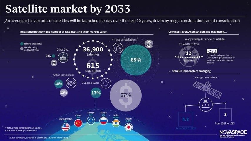
The 27th edition of the Novaspace "Satellites to be Built and Launched” report forecasts that an average of over 3,700 satellites will be launched annually between 2024 and 2033 – equivalent to 10 satellites per day. Keeping track of all those satellites, not to mention all of the accumulated space debris in low, medium and geostationary Earth orbit, is only going to get more complex.
Yes, space is a big place. But it’s also getting more crowded by the day, and everything in orbit moves very fast. Some satellites are becoming more agile, so predicting their positions in space is also getting more complicated. So, Space Situational Awareness will be increasingly important to the companies that build and launch satellites, the investors who spend a lot of money to get them into orbit, and the users of the data who depend more and more on accurate information for communications, navigation, and smart business decisions.