

Φsat-2 Begins Science Phase
ESA CubeSat was Launched in August 2024

An ESA miniature satellite called Φsat-2 has completed its commissioning and has begun delivery of science data, using algorithms to efficiently process and compress Earth observation images, as well as detect wildfires, ships, marine pollution and more.
“As often happens, we realized during the commissioning phase that there were ways of making the mission more interesting for AI developers."
Nicola Melega, ESA
The cubesat was launched in August 2024 and the first image was delivered four days after launch. Since then, the Φsat-2 team has spent nine months commissioning the satellite’s multispectral imager and its onboard AI applications, which carry out a range of activities.
These AI capabilities include selecting images with clear visibility, while discarding images obscured by cloud cover. The algorithms can also detect and analyse disaster areas, for example zones affected by wildfires, earthquakes or floods, and identify access routes for emergency response teams. It can also be used to detect ships, gather data on illegal fishing and marine pollution. Commissioning was concluded in the second quarter of this year and the satellite is now delivering scientific data.
The satellite orbits at an altitude of 510 km (≈317 miles). It generates images using seven multispectral bands, from visible to near-infrared, as well as one panchromatic band, with a ground sampling distance of about 5 m (16 feet). This type of remote-sensing instrument is particularly useful for environmental monitoring, land management and mapping.
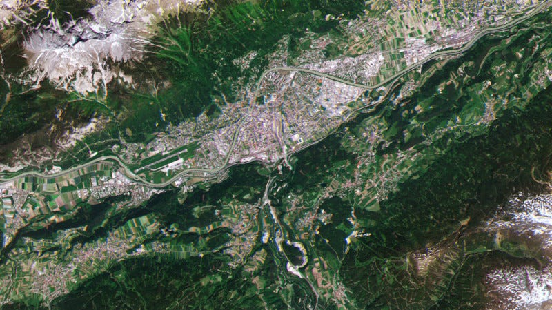
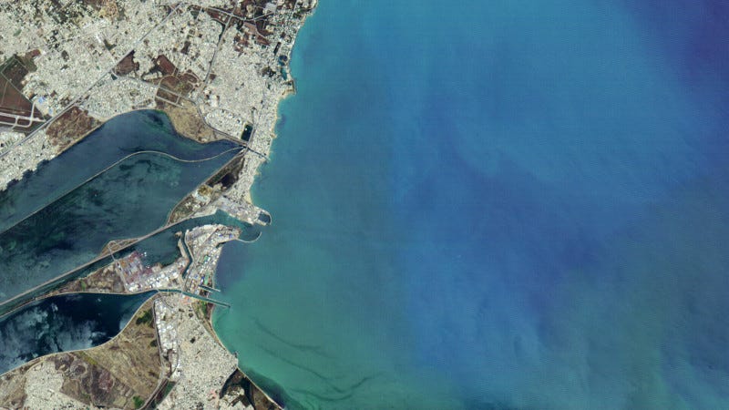
To mark the transition from commissioning to science phase, five images have been selected to show a range of capabilities for various end-uses over diverse types of terrain. All images are true colors using red, green and blue spectral bands, except for the image of the Bahia Blanca Estuary, which is a false color using the near-infrared spectral band.
Clavering Øer glaciers, Greenland
Bahia Blanca Estuary, Argentina
City of Innsbruck, Austria
Sediment in Gulf of Tunis, Tunisia
Ships in Port Said, Egypt
Φsat-2 was designed with the purpose of demonstrating and testing the use of onboard AI in Earth observation. According to Nicola Melega, ESA Earth observation system engineer and responsible for commissioning Φsat-2, the initial plan was to process data onboard and then transmit information generated by the AI applications back to Earth. Nicola said, “As often happens, we realized during the commissioning phase that there were ways of making the mission more interesting for AI developers and instead of making available only the end results of the onboard processing chain (Level 2 data) we now provide users with an entire collection of Level 1 data products that will help the application development and the training process.”
The ground segment is provided by Open Cosmos and CGI Italy; while Kongsberg Satellite Services (KSAT) provides a ground station service, mainly from antennas in Svalbard. Data are made available on the Insula platform by CGI Italy – and are freely available to anyone who wants to register (requests for registration should be sent to insula-info.it@cgi.com).
Φsat-2 is still a demonstrator mission: it is designed to find the limitations and gaps in new technology. “But its purpose is also to build our understanding of the processes. We can check the performance of the applications and we can also see what resources are needed to manage the mission and process the data,” Nicola said.