

Rising Demand for Geospatial Intelligence Drives Commercial Satellite Imagery Market
Forecast to Climb to $15.29 Billion by 2032

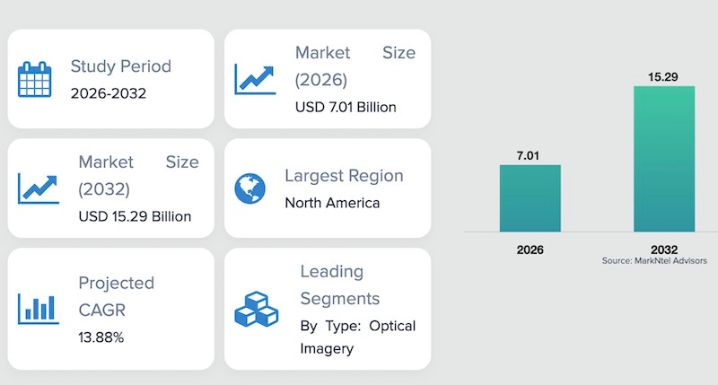
The Global Commercial Satellite Imagery Market is projected to grow from $7.01 billion in 2026 to approximately $15.29 billion by 2032 at a CAGR of around 13.88%, reflecting strong market expansion supported by the increasing adoption of satellite imagery for surveillance, mapping, environmental monitoring, and resource management. According to a market research study published by MarkNtel Advisors, the market expansion is primarily being driven by the increasing demand for high-resolution geospatial intelligence across defense, environmental monitoring, agriculture, and infrastructure planning.
In addition, the growing deployment of satellite constellations, advancements in Earth observation technologies, and rising adoption of satellite-based analytics for real-time monitoring are significantly contributing to the expansion of the commercial satellite imagery industry.
Regionally, North America leads the Global Commercial Satellite Imagery Market, accounting for approximately 45% of the total market share in 2026. The region’s leadership is supported by the strong presence of leading satellite operators and Earth observation companies, high defense and intelligence spending, advanced space infrastructure, and increasing demand for geospatial analytics across government, commercial, and environmental monitoring applications.
One of the key factors driving the growth of the commercial satellite imagery market is the rapidly increasing demand for geospatial intelligence across a wide range of industries, including defense, agriculture, environmental monitoring, and infrastructure management. Governments and private organizations are increasingly utilizing satellite imagery to obtain accurate and real-time geographic insights that support strategic decision-making, resource planning, and risk assessment.
Satellite imagery enables large-scale monitoring of vast geographic areas that are often difficult or costly to assess using traditional data collection methods. As a result, it plays a critical role in applications such as tracking environmental changes, monitoring deforestation, evaluating crop health, and analyzing infrastructure development. These capabilities have positioned satellite-based Earth observation technologies as essential tools for modern data-driven industries.
Despite the strong growth potential of the market, several challenges continue to influence the broader adoption of commercial satellite imagery services. One of the primary limitations is the high cost associated with satellite development, launch operations, maintenance, and the acquisition of high-resolution imagery data.
The deployment of advanced imaging satellites requires substantial capital investment, which may limit participation for smaller organizations and emerging space technology firms. Additionally, regulatory restrictions related to satellite imaging resolution, data security, and national security considerations in certain countries can affect the distribution and commercialization of satellite imagery data.
Moreover, environmental factors such as cloud cover and atmospheric conditions may occasionally impact the quality of optical satellite imagery, particularly in regions with frequent weather disturbances. In such cases, alternative imaging technologies such as Synthetic Aperture Radar (SAR) are often required to ensure reliable data collection.
Nevertheless, ongoing advancements in satellite technologies, increasing investments in global space infrastructure, and expanding collaboration between governments and private satellite operators are expected to gradually mitigate these challenges. These developments are likely to improve accessibility and efficiency in satellite data acquisition, thereby supporting the sustained growth of the commercial satellite imagery market.
Other key takeaways from the report:
By type, the optical imagery segment accounted for approximately 64% of the Global Commercial Satellite Imagery Market share in 2026, driven by its widespread application in mapping, urban planning, agricultural monitoring, and infrastructure development. Optical satellite imagery offers high visual clarity and detailed spatial insights, making it one of the most widely used data sources for geospatial analysis across multiple industries.
By end user, the government & defense segment held a major share of around 48% of the Global Commercial Satellite Imagery Market in 2026, reflecting the growing reliance on satellite imagery for national security operations, border monitoring, disaster response, and intelligence gathering.
The presence of leading Earth observation companies continues to strengthen the competitive landscape through the development of advanced imaging satellites, expansion of satellite constellations, and integration of artificial intelligence and cloud-based analytics platforms for enhanced geospatial intelligence capabilities.