

Project Centinela Launched by Planet
Delivering Satellite-Derived Tools and Insights to Conservationists and Scientists

A new program aiming to equip the world’s leading biodiversity scientists and conservation advocates with high-frequency satellite imagery, analytics, and planetary variables has been introduced by Planet. Called Project Centinela, the program will help support teams working at the forefront of the biodiversity crisis to monitor and safeguard up to 50 of the world’s vulnerable biodiversity hotspots.
"We now have the tools to tackle the biodiversity crisis at speed and scale.”
Andrew Zolli, Planet
Planet owns and operates the largest constellation of Earth imaging satellites in history, capturing the Earth on a near-daily cadence. This high-frequency satellite imagery enables communities and researchers to see Earth’s changing surface, characterize ecosystem health, and track the success of conservation and restoration efforts over time. With access to Planet’s Planetary Variables, such as Forest Carbon, Soil Moisture, and Land Surface Temperature, Project Centinela participants will have a unique suite of tools to derive quantifiable insights that advance conservation of their target sites.
“Time is of the essence. Ecosystems around the world are in peril, and we risk losing some of Earth’s most iconic species. We now have the tools to tackle the biodiversity crisis at speed and scale,” said Planet Chief Impact Officer Andrew Zolli. “Leveraging daily satellite data and modern AI, we can monitor critical hotspots and tackle threats before it’s too late. The biggest challenges remain around access to this data, and Project Centinela is leading the way in getting these game-changing tools into the hands of scientists and stewards around the world.”
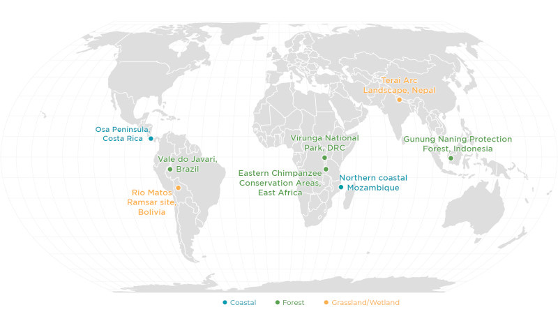
At its onset, Project Centinela has already engaged teams in eight biodiversity-vulnerable locations across the globe including: the Osa Peninsula in Costa Rica, Vale do Javari in Brazil, Rio Matos Ramsar site in Bolivia, Virunga National Park in the Democratic Republic of the Congo, Eastern Chimpanzee Conservation Areas in western Tanzania and Uganda, northern coastal Mozambique, Terai Arc Landscape in Nepal, and Gunung Naning Protection Forest in Borneo, Indonesia.
“In the hands of communities, decision makers, and researchers, Planet's powerful imagery and tools help us see Earth's changing surface, characterize ecosystem and biodiversity conditions, and track the success of conservation and restoration efforts over time,” said Amy Rosenthal, Planet's Senior Global Director for Conservation Initiatives.