

Partnership Formed to Advance 3D Earth Observation Capabilities
Array Labs, Umbra Space, and Raytheon Will Collaborate on the Project

A strategic three-way teaming agreement to accelerate the development and deployment of advanced 3D Earth observation capabilities has been announced. The collaboration among Array Labs, Umbra Space, and Raytheon, an RTX business, aims to accelerate the delivery of 3D geospatial products to commercial and government customers.
"Site3D represents a commitment to solving real-world problems for customers today while building towards the end state of a real-time, high-fidelity 3D map of Earth."
Andrew Peterson, Array Labs
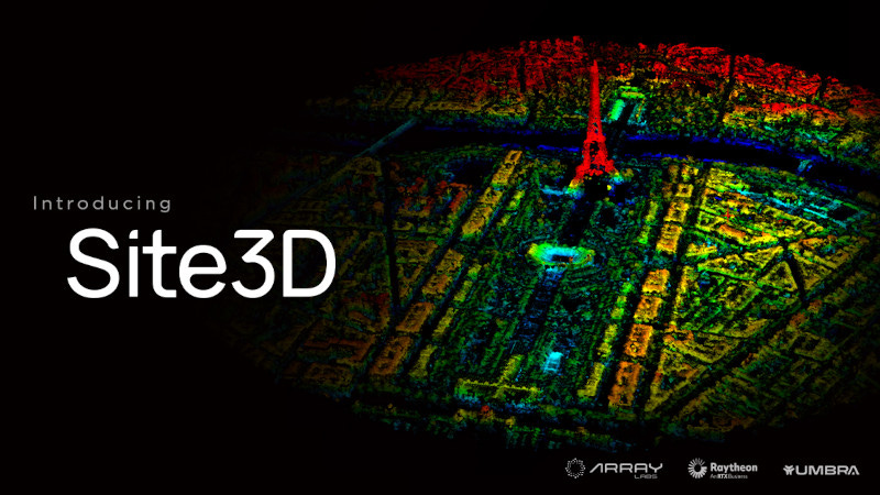
Site3D, the flagship product of this collaboration, combines state-of-the-art synthetic aperture radar (SAR) technology with advanced mapping algorithms to create three-dimensional models of the Earth's surface. These SAR point clouds can also be used to generate digital surface models (DSMs) and facilitate automated volumetric estimation and change detection.
The Site3D product is designed for high-value landscapes and facilities, offering customizable tasking with support for regular revisits, monitoring use cases, and change detection capabilities.
Slated for commercial release in the coming months, Site3D represents a novel approach to market entry, bridging the gap between concept and full-scale deployment in the new space industry. By combining the team's collective experience and expertise in space systems, defense, and advanced imaging technologies, the collaboration aims to expand the customer base for 3D data and accelerate its adoption across diverse industries.
"As teammates, Raytheon and Umbra provide the ideal combination of technical savvy and strategic conviction, which will help us educate customers, bring 3D data products to market faster, and launch our own satellite imaging clusters," said Array Labs CEO Andrew Peterson.
"Ultimately, Site3D represents a commitment to solving real-world problems for customers today while building towards the end state of a real-time, high-fidelity 3D map of Earth," added Peterson.
"Raytheon's precise 3D processing algorithms, developed over two decades of working with electro-optical imagery, are now being adapted in collaboration with Array Labs for SAR applications. This opens exciting new opportunities in commercial SAR and allows us to achieve accurate results, unrestricted by cloud coverage," said Erich Hernandez-Baquero, vice president, Space Intelligence, Surveillance & Reconnaissance (SISR) for Raytheon.
"Array and Raytheon have transformed our data into a totally new product applicable to customers we never would have known existed, let alone reached, without them. Their creativity and effort to crack open new opportunities with this 3D product has been tremendously fun to watch from behind the scenes," said Umbra VP of Remote Sensing Joe Morrison.
The team is focused on validating and enhancing the underlying technologies that power Site3D. The collaboration will also see the companies jointly develop advanced automated tasking, 3D analytics, visualization, and volumetric measurement tools.
Frequent assessment of critical structures, rapid volumetric characterization for asset monitoring, 3D modeling for risk assessment, and updated terrain data for enhanced situational awareness are among the most anticipated applications for Site3D.
Together, the team looks forward to rapidly evolving Site3D, in support of commercial, defense, intelligence, and civilian geospatial applications.