

Optical SDA Sensor Clears Thermal Vacuum Testing for Blue Ring Commercial GEO Mission
Week-Long Test Campaign Marks Final Environmental Verification of 13.8-Inch Narrow-Field Payload

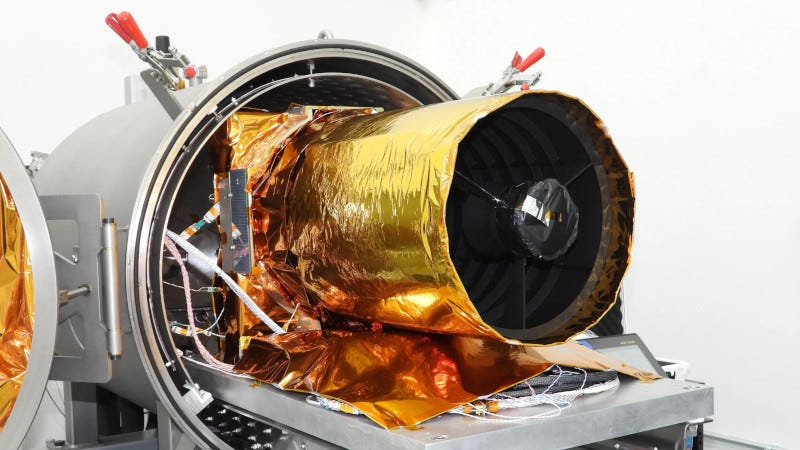
A 13.8-inch (35cm) electro-optical space domain awareness sensor has completed a week-long thermal vacuum test campaign, clearing the final environmental verification milestone ahead of its planned flight on Blue Origin’s Blue Ring spacecraft.
“The successful completion of this T-Vac campaign represents a significant risk reduction milestone for the CoBR program.”
John Hildebrand, Optimum Technologies
Optimum Technologies (OpTech) of Sterling, Va., announced the completion of the thermal vacuum (T-Vac) test campaign for its Caracal on Blue Ring (CoBR) program, marking a key step in system verification and flight readiness. Mission data — including metric observations and resolved satellite imagery — is expected later this year.
The test campaign was conducted at OpTech’s own environmental test facility, where CoBR hardware was subjected to a comprehensive range of thermal and vacuum conditions designed to replicate the space environment. The system demonstrated performance across all planned test cases, validating both design integrity and operational functionality under mission-representative conditions.
“The successful completion of this T-Vac campaign represents a significant risk reduction milestone for the CoBR program,” said John Hildebrand, COO at Optimum Technologies. “Our team executed a disciplined and efficient test program, reinforcing confidence in the system’s readiness for subsequent integration and flight operations.”
OpTech’s integrated test and evaluation (I&T) capabilities enabled rapid test execution, real-time data analysis, and streamlined anomaly resolution, keeping the program on schedule and meeting performance objectives.
Caracal’s Role in the CoBR Mission
The Caracal payload is a narrow-field-of-view electro-optical imager built for space domain awareness operations in geostationary orbit (GEO), approximately 22,236 miles above Earth. The CoBR program pairs the sensor with Blue Ring, a multi-mission spacecraft developed by Blue Origin’s In-Space Systems business unit, for what the companies have described as the first fully commercial GEO space domain awareness mission.
Blue Ring is designed to support payload hosting, delivery, and mission operations across a range of orbital destinations, with its first mission scheduled for 2026. With thermal vacuum testing complete, CoBR hardware will now transition to the next phase of integration and pre-launch preparation.
TVAC testing is among the most demanding qualification steps in a spacecraft program, cycling hardware through extreme temperature and pressure swings to verify it can survive and operate in the vacuum of space. Completing the campaign at OpTech’s in-house facility allowed the engineering team to maintain real-time oversight of data and resolve any anomalies without the delays associated with shipping hardware to an external test site.
Expanding the Caracal Manifest
The CoBR milestone comes as OpTech advances a second Caracal payload for the U.S. Space Force’s Tactically Responsive Space program under the VICTUS SURGO mission. Testing and delivery of that unit are planned for this summer.
OpTech is also developing a Caracal II, an upgraded variant intended for future U.S. government GEO Space Situational Awareness (SSA) missions. The progression from CoBR through VICTUS SURGO to Caracal II reflects a deliberate path toward establishing a recurring commercial and government market for persistent geostationary monitoring.
GEO hosts much of the world’s critical infrastructure — communications, weather monitoring, and navigation satellites — making tracking and characterization of all objects operating or drifting at that altitude a growing priority for national security agencies and commercial operators alike. The CoBR mission targets exactly that operational gap, with Caracal designed to conduct both metric tracking and high-resolution imagery of resident space objects from geostationary altitude.