

NGA Awards IDIQ Contract to Maxar
One of 10 Vendors Selected for Luno A Program

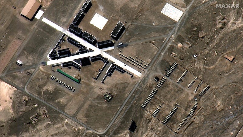
The National Geospatial-Intelligence Agency (NGA) has selected Maxar Technologies as one of 10 vendors to provide advanced geospatial insights and automated object detections through NGA’s Luno A, a $290 million, five-year indefinite delivery, indefinite quantity (IDIQ) contract.
“Our very-high resolution imagery and massive data library give us a unique edge to meet Luno A’s need for fast, accurate insights.”
Susanne Hake, Maxar
Under this contract, Maxar will leverage its highly refined computer vision models to deliver accurate, automated object detections and analytic insights. Powered by the highest-resolution electro-optical commercial satellite imagery, Maxar’s vast 20-year imagery archive and precise geolocation are differentiated assets primed for Luno A’s operational demands.
“Our very-high resolution imagery and massive data library give us a unique edge to meet Luno A’s need for fast, accurate insights,” said Susanne Hake, General Manager, U.S. Government at Maxar. “As we continue launching more WorldView Legion satellites, we’ll have significantly more 30 cm-class imaging capacity and increased revisits, providing us with an even deeper pool of exquisite data that can fuel more actionable insights in near real-time."
NGA selected 10 vendors, including Maxar, for the five-year IDIQ, reinforcing the key role commercial providers play in making sense of geospatial data at scale. This industry partnership will enhance NGA’s ability to detect and track vehicles, aircraft, vessels, and infrastructure, as well as monitor patterns of life, economic indicators, and changes to critical facilities and terrain.
Maxar has already begun work with NGA under the Luno A contract, helping analysts and operators better understand changes on Earth and respond to global developments.
Luno A is a follow-on to the Economic Indicator Monitoring contract, which focused on managing the deluge of data by purchasing commercial data as services to integrate with NGA machine learning and artificial intelligence efforts. Luno A will expand access to data and services for the National System for Geospatial Intelligence, accelerate analytic workflow modernization objectives and integrate data and services into enterprise capabilities.