

Japan to Develop Digital National Basemap via Satellite
Axelspace Web Platform Service to Contribute to the Project

The Geospatial Information Authority of Japan will develop a digital national basemap via satellite images acquired by AxelGlobe in-orbit satellites, GRUS. The Earth observation web platform service “AxelGlobe” was selected by the agency to assist in improving the efficiency of map updates by utilizing satellites and AI.
"The Digital National Basemap is an important database serving as a foundation of Japanese society."
Tatsuhiko Fukasawa, AxelGlobe
Axelspace is the sole operator of an optical satellite constellation in Japan. The digital national basemap is a foundational map in a digital format created by the Geospatial Information Authority of Japan (GSI) to standardize the map measurement of Japan’s land.
It serves as the fundamental data for maps utilized by both public and private sectors, supporting various use cases such as car navigation systems, map apps, and hazard maps. Therefore, the basemap development and the promotion of its usage are acknowledged as the priority measures of the government.
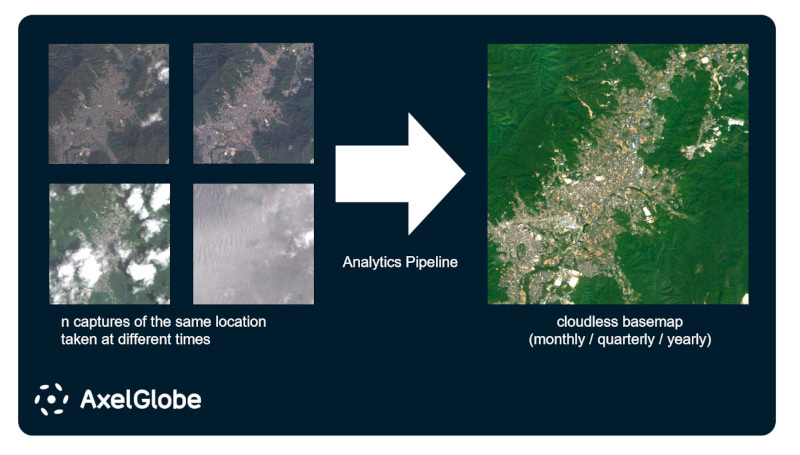
With the aim of enhancing the productivity of these activities, GSI has been developing technology for extracting areas of change from both satellite images captured at two distinct time points and AI-generated image analyses. AxelGlobe will support this initiative by providing “cloudless” satellite imagery data showing the latest status of Japan’s land features.
"The Digital National Basemap is an important database serving as a foundation of Japanese society, and we believe the selection of AxelGlobe results from high evaluation of its reliability and flexibility," said Tatsuhiko Fukasawa, Director and Head of AxelGlobe Business Division. "We will continue to contribute to GSI’s projects by providing valuable services from AxelGlobe.
AxelGlobe is an Earth observation platform powered by GRUS, the five AxelGlobe satellites currently in orbit, allowing anyone to access satellite data from their computers. GRUS can observe the same point on Earth at intervals of 2-3 days with ground resolution of 2.5 meters, which is sufficient to identify large aircrafts parked on the ground in the captured images.
Taking advantage of the precise attitude control performance of GRUS, it can provide data across the globe on a tasking basis to meet user demands. As for this project, AxelGlobe developed a new product called “AxelGlobe Mosaic” which generates cloudless satellite imagery data by compiling multiple captures of the same location.