

Greek Wildfire Satellite Returns First Thermal Images
Hellenic Fire System Reaches Milestone Less Than a Month After Launch

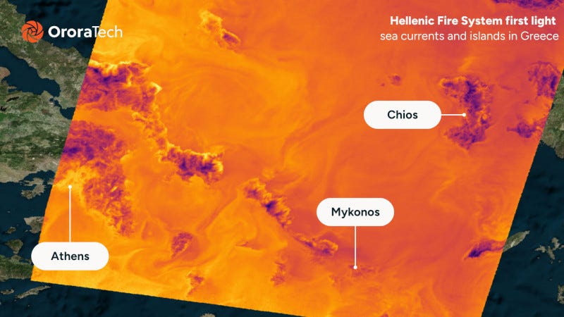
A satellite built to help detect wildfires across Greece has returned its first thermal images, less than one month after launch.
“This milestone shows our ability to rapidly bring sophisticated space assets into service while providing the high-quality thermal data needed for wildfire detection, environmental monitoring, and scientific research.”
Martin Langer, OroraTech.
The spacecraft, known as the Hellenic Fire System, captured the image following two weeks of calibration, according to a news release from OroraTech, the Munich-based company supplying the thermal sensors. The image shows the Athens metropolitan area, the islands of Andros, Tinos, Skyros, Chios, Kea and Kythnos, and thermal patterns in the Aegean Sea created by ocean currents.
The satellite is the first in a planned constellation that, once fully deployed, is intended to scan all of Greece twice daily. For now, the system remains in its early commissioning phase, and OroraTech’s release does not specify how many satellites will ultimately make up the constellation or when full operational capability is expected.
“This milestone shows our ability to rapidly bring sophisticated space assets into service while providing the high-quality thermal data needed for wildfire detection, environmental monitoring, and scientific research,” said Martin Langer, CEO of OroraTech.
The project is being carried out under a European Space Agency contract as part of the Greek National Satellite Space Project, identified in program documents as Measure ID 16855. The project is implemented by Greece’s Ministry of Digital Governance and Artificial Intelligence, with ESA providing management and implementation assistance. Funding comes through the National Recovery and Resilience Plan “Greece 2.0,” backed by the European Union’s Recovery and Resilience Facility.
Once operational, the system is intended to support wildfire detection and emergency response, as well as generate land-surface-temperature data for climate researchers studying the Mediterranean region.