

Google Earth AI imagery Incorporated into Vantor Tensorglobe
Imagery Models Will Also Be Integrated into Vantor’s Mission Applications

An agreement has been signed that will allow for the integration of Google Earth AI imagery models into the Vantor Tensorglobe platform, expanding the analytical capabilities available to sovereign governments operating in sensitive and classified environments as they deliver on civil, humanitarian, and security missions.
Through this integration, Vantor becomes the first spatial intelligence company to deploy Google Earth AI models in air-gapped government environments. Vantor can fine-tune and retrain these models using a customer’s sovereign data—combining Vantor satellite imagery, third-party commercial imagery, and a customer’s own remote sensing sources—to unlock more advanced, integrated intelligence.
These capabilities support a range of operational use cases, including:
Site monitoring and broad area monitoring
Operational pattern analysis and anomaly detection
Decision support for planning and resource allocation
Geospatial change detection and infrastructure monitoring
Damage assessment and recovery tracking
Foundational mapping
Collection planning and tasking decision support
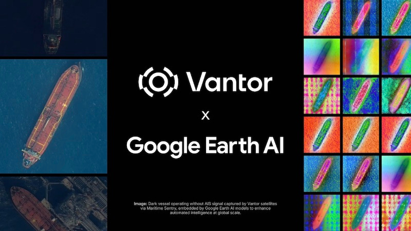
The Earth AI imagery models will also be integrated into Vantor’s mission applications, beginning with Sentry, to support persistent site monitoring and broad-area maritime monitoring workflows.
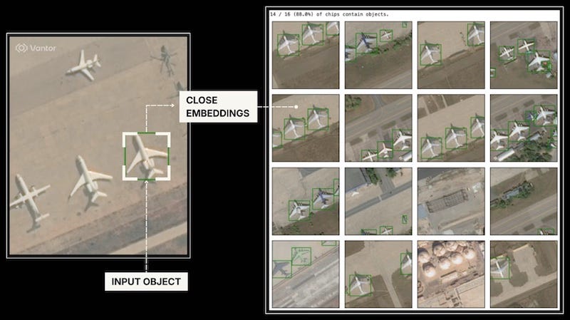
Google’s Earth AI models represent a breakthrough in geospatial AI, leveraging proven architectures trained on massive datasets of satellite and aerial imagery to accurately map buildings and roads, locate specific objects and features, assess post-event damage, semantically understand scenes, and more.
This integration marks the first time Earth AI imagery models have been deployed commercially against a dataset with the scale, accuracy, and temporal depth of Vantor’s AI-ready spatial foundation, which includes highly accurate, global-scale 2D and 3D data.
Combining the power of Earth AI imagery models with the scale, depth, and quality of Vantor satellite imagery, Vantor customers can rapidly unlock complex and valuable use cases.
Vantor’s spatial foundation covers virtually all of Earth’s landmass in 2D and 95% of the highest areas of interest in 3D. The foundation is supported by a 20-plus-year archive of high-resolution satellite imagery, including the deepest archive of 30 cm-class imagery available commercially. That foundation is continuously refreshed by Vantor’s imaging satellite constellation, which can revisit the same location on Earth up to 15 times per day, providing a consistent, current baseline for automated analysis and change detection.
Collectively, this foundation represents an unmatched planetary-scale dataset for AI systems.
Many state-of-the-art AI models are limited to public cloud deployments. Through this partnership, Vantor can deploy Earth AI models wherever customer missions require, including sovereign, on-premises, and air-gapped environments.
Tensorglobe enables training and fine-tuning of Earth AI models locally with a customer’s own sensor data and private archives. When combined with Vantor’s automated spatial fusion and production capabilities, this approach allows organizations to build analytics pipelines and process multi-sensor data in near real-time—detecting objects of interest, identifying patterns of change, and describing activity with operational context.
This integration reflects Vantor’s broader approach to spatial intelligence: combining proprietary data advantages, operational software, and best-in-class AI models to deliver useable intelligence where and how missions demand it.
As Google continues to advance Earth AI imagery models, Vantor customers will be positioned to adopt those capabilities quickly within their own environments, using their own data and aligned to their operational needs.
Reach out below to learn more about how Vantor’s partnership with Google can accelerate your missions.