

Geologic Martian Maps Released by USGS

The USGS Astrogeology Science Center in Flagstaff, Arizona recently released a series of geologic Martian maps that could all be impactful to future missions to the Red Planet. Does size matter? In this case, yes. Size, or scale, is an important feature when building a geologic map.
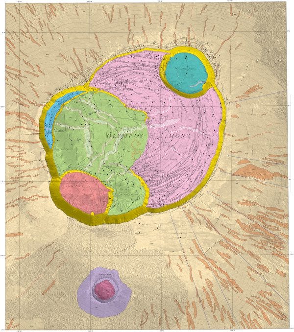
“Probably the most interesting thing about the map is the addition of the contours (Mars maps almost never have this) and these contours have allowed the identification of the late-stage inflation of the summit (in other words, the contours show that some young lava flows appear to flow uphill).”
Dr. Peter Mouginis-Mark (University of Hawaii Manoa).
Small-scale maps cover relatively large areas and to date, are the most common scale of geologic map in planetary science. These are often completed at scales of between 1:500,000 to 1:5,000,000. For reference, a 1:500,000 scale map means that 1 mm on the map equates to 500,000 mm (or 500 km/310 miles) on a planet’s surface. Though maps have historically covered large areas, with crewed lunar missions on the horizon and other missions across the solar system in the planning stages, large-scale, small-area maps are starting to steal the limelight. These large-scale, small-area maps provide highly detailed views of the surface and allow scientists to investigate complex geologic relationships both on and beneath the surface. These types of maps are useful for both planning for and then conducting landed missions.
Olympus Mons is the tallest volcano in the solar system, but a new map of the caldera by Dr. Peter Mouginis-Mark (University of Hawaii Manoa) revealed a surprise - the highest point isn’t where you would expect. This new detailed geologic Martian map highlights the complex volcanologic history of the caldera and builds on Dr. Mouginis-Mark’s past work which found multiple caldera collapses had occurred in Olympus Mons’ past. Dr. Mouginis-Mark thinks this could explain the curiosity of Olympus Mons’ highest point.
“Probably the most interesting thing about the map is the addition of the contours (Mars maps almost never have this) and these contours have allowed the identification of the late-stage inflation of the summit (in other words, the contours show that some young lava flows appear to flow uphill),” Dr. Mouginis-Mark said.
Other Insights from the USGS Geologic Martian Maps
Approximately 5,000 kilometers (≈3,100 miles) to the west of Olympus Mons is the Aeolis Dorsa (Greek and Latin, respectively, for “Wind Ridge”) region of Mars. This geologically diverse area is around the size of the state of Arizona and has a complex depositional history. Much like on Earth, sediments on Mars were primarily deposited by wind, flowing water, or ice. One particularly interesting feature revealed by the geologic Martian maps that hints at Mars’ watery past is the sinuous ridge, which is a winding, narrow ridge that looks like an inverted river channel. These ridges are interpreted to be aqueous (formed by water), making them possible clues about the history of water on Mars. Aeolis Dorsa is not lacking in sinuous ridges - in fact, it has hundreds of them to study. Dr. Devon Burr (Northern Arizona University) and colleagues recently completed a new map of the Aeolis Dorsa region with these fluvial (river) features in mind. “The original motivation for this map was to try to understand the history of these numerous inverted fluvial features,” Dr. Burr said.
Although Aeolis Dorsa has spectacular fluvial features, it is not the only location on Mars with possible fluvial systems. Fluvial systems and floods go hand in hand, and there are many areas on Mars that may have experienced flooding in the past. The Athabasca Valles region of Mars was long thought to be the result of a large flood. However, there was much debate about whether the features in this area were from a flood of water or a large eruption of blisteringly hot, runny lava. Today, many scientists interpret the terrains in the Athabasca Valles as young flood basalts, with the geologically recent Athabasca Valles “flooding” event flowing across the landscape, leaving a series of detailed, pristinely preserved geologic interactions visible in the region.
(Images provided with USGS news article)