

First Light Images from FireSat Protoflight Released
Spacecraft Launched by Muon Space Aboard Transporter-13 Mission


The first light images from the Muon Space FireSat Protoflight have been released, marking a significant milestone in the development of the world's first dedicated wildfire detection and monitoring constellation. The images, captured by Muon's six-channel multispectral infrared (IR) instrument, demonstrate the exceptional capabilities of this IR technology for detecting and monitoring thermal activities.
"These first light images confirm that our IR sensors are operating as designed and collecting high-quality data."
Dan McCleese, Muon Space
Launched on March 14th aboard SpaceX's Transporter-13 mission, the FireSat constellation is a collaboration between Muon and the nonprofit Earth Fire Alliance to enhance global wildfire response by delivering actionable data to first responders, policymakers, and communities facing escalating wildfire threats. The satellite's six-channel multispectral IR instrument – designed and built in-house – places Muon among a select group of commercial companies capable of developing and operating advanced space-based thermal sensors. Capturing IR imagery validates both the instrument and Muon's vertically integrated satellite platform.
"The FireSat first light images demonstrate Muon's approach to building mission-optimized satellites including purpose-built instruments," said Jonny Dyer, CEO of Muon Space. "I'm ecstatic with both the speed at which we moved from FireSat mission formulation to an orbit demonstration and the quality of the data that we are now collecting."
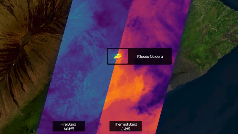
Captured in June 2025 using FireSat Protoflight's multispectral infrared sensors, our first imagery set reveals urban heat islands, airport runway activity, and water temperature variations in Sydney, Australia; lava fountains at Hawaii's Kīlauea volcano; and gas flares at Libya's Sarir oil field complex.
"These first light images confirm that our IR sensors are operating as designed and collecting high-quality data," said Dan McCleese, Chief Scientist of Muon Space. "Infrared imaging with this quality is one of the most technically demanding domains in remote sensing, and we're proud to be among the few commercial players advancing this capability in orbit."
FireSat is capable of multispectral imaging across the visible, near-infrared, short-, mid- and long-wave infrared bands simultaneously. High-fidelity IR data is essential for detecting wildfires in their early stages, monitoring fire dynamics, and tracking other thermal anomalies. FireSat addresses a longstanding gap in space-based wildfire monitoring by delivering persistent, high-resolution, actionable intelligence to government and commercial users.
Distinguished by its high-dynamic range (HDR) multispectral IR instrument, the FireSat Constellation is uniquely equipped to differentiate genuine wildfire events from false positives and enhance the accuracy and reliability of wildfire detection and assessment of fire intensity. The FireSat constellation will operate in LEO with an observation swath width of 1,500 km (≈932 miles) and a nadir ground sample distance of 50 meters (≈55 yards). The instrument's resolution, sensitivity and large dynamic range enable it to detect small cool fires 5x5 meters (≈16x16 feet) while also imaging without saturation for hot intense fires.
As the demonstration mission for a planned 50+ satellite constellation, FireSat Protoflight will soon begin providing high-resolution thermal infrared data to meet growing demand across government, commercial, and environmental sectors. The full constellation will deliver global coverage, with each point on Earth observed every 20 minutes and key wildfire-prone regions benefiting from more frequent observations. The FireSat initiative is led by the Earth Fire Alliance and supported by Google Research, along with leading NGOs and philanthropic organizations including Google.org, the Gordon and Betty Moore Foundation, and the Environmental Defense Fund.